Image from: Wikimedia Commons
In my last post I talked a lot about how wind shear helps fuel storms. So in this post I decided to explain wind shear a little more in depth.
If you follow weather you have heard the term wind shear over and over again. It gets mentioned during severe weather coverage, in forecasts, and anytime people start talking about tornado potential. It sounds like complicated weather term, but the idea is actually pretty simple; wind shear is just a change in the wind as you go higher in the atmosphere. That change can be speed, direction, or both. So say down at the ground the wind is out of the south at 15 mph. A few thousand feet up, it is southwest at 40 mph. Higher than that, it is ripping out of the west even faster. Same sky and same storm environment, but different winds at different levels. That is wind shear and it matters a lot more than people realize.
The atmosphere is made up of layers that are not all dealing with the same things. Near the ground, wind gets slowed down by friction from a neighbor’s house, trees, and even the surface itself. Surface winds can also be shaped by temperature differences and pressure patterns. Higher up, the wind is more tied to the bigger picture. That is where upper level systems and the jet stream really start showing their power. So it is common for winds at the ground and winds aloft to be doing totally different things. That may not seem like a big deal, but for thunderstorms it can be the difference between a quick rain shower or a supercell.
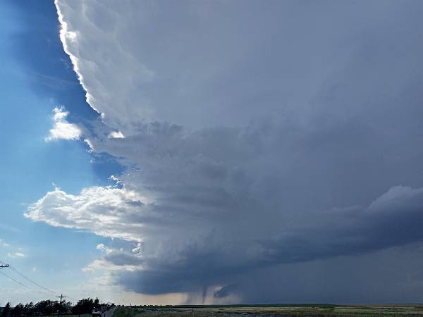
Storms run on warm moist air that rises into the storm, that rising air is called the updraft. If there isn’t much wind shear, storms will most likely flow straight up, causing the rain and cooled air to fall right back into the same area feeding the storm. It basically starts choking itself off. But when there is good wind shear, the storm can tilt. Now the rain and downdraft are pushed away from the updraft. The storm is not suffocating itself anymore and has space to keep going, keep organizing, and keep pulling in warm unstable air.
That is where things can escalate.
When you combine instability with strong wind shear, storms can become severe. They can last longer, grow stronger, and become more organized. Sometimes that means damaging straight line winds. Sometimes large hail. Sometimes rotating storms called supercells. And in the right setup, tornadoes. This is why meteorologists do not just look at temperature and humidity. You can have plenty of fuel in the atmosphere, but if the wind profile is weak, storms may never do much. Other times the ingredients line up and the winds with height are doing exactly what you do not want to see.
Without shear, storms can struggle.
With shear, storms can mean business.
💬 Comments